



The United Nations General Assembly has voted overwhelmingly in favour of a resolution encouraging the use of world maps that more accurately represent the relative size of Africa and other continents.
The “Correct the Map” resolution, sponsored by Togo and backed by members of the African Union, was supported by 164 countries, including France and the United Kingdom. The United States was the only country to vote against the resolution, while Estonia, Georgia, Lithuania, Moldova, Serbia and Ukraine abstained.
Although the resolution is non-binding, it encourages governments, schools, international institutions and technology companies to move away from map projections that significantly distort the relative size of countries and continents. The campaign has focused particularly on the Mercator projection, which has been widely used since the 16th century.
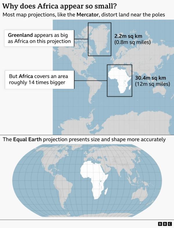
Designed in 1569 by Flemish cartographer Gerardus Mercator to assist navigation, the projection preserves angles and directions but significantly enlarges land masses closer to the poles while making areas around the equator appear relatively smaller.
As a result, Greenland can appear similar in size to Africa on a Mercator map, despite Africa covering roughly 14 times more land. Supporters of the resolution argue that such distortions have influenced perceptions of Africa’s geographical importance, population, resources and economic potential.
In 2018, cartographers developed the Equal Earth projection, an equal-area map designed to represent the relative sizes of continents and countries more accurately. The African Union’s 54 member states adopted the projection in February, saying it “more accurately represents the sizes of all continents, particularly Africa.”
Campaign group #CorrectTheMap has highlighted the continent’s scale, saying: “You could fit the United States, China, India, Japan, Mexico and much of Europe into Africa and still have land to spare.” Ahead of Friday’s General Assembly vote, Togolese Foreign Minister Robert Dussey said the campaign was about correcting long-standing perceptions created by distorted maps. “A fair world begins with a fair map,” Dussey told Reuters.